Belzec Excavations
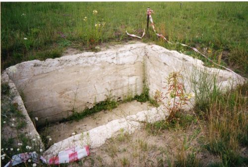
Belzec - Generator Housing - July 2000 (Chris Webb Private Archive)
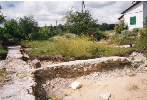
Belzec Foundations -July 2000 (Chris Webb Private Archive)
Introduction
The investigation carried out at Bełżec by leading archaeologists was historically important. Although investigations have been undertaken in all three death camps, which formed part of the Aktion Reinhardt mass murder programme, the results of the excavations at Belzec during 1997 and 1999, were contained in a publication by the group's leader Professor Andrzej Kola, from the University of Torun, Poland. The publication was titled: 'Belzec - The Nazi Camp for Jews in the Light of Archaeological Sources - Excavations 1997-1999'.
The archaeological investigations carried out by Professor Kola and his team confirmed by overwhelming evidence that mass murder was committed at Belzec, and that there was a determined effort by the Nazis to conceal the enormity of the crime. The excavations also helped to determine the locations of mass graves, and confirm the probable layout of the camp, during the first and second phases.
Previous Investigations
The 1997 archaeological investigations at Bełżec were initiated by an agreement between the Council for the Protection of Memory of Combat and Martyrdom (Rada Ochrony Pamieci Walk I Meczenstwa – ROPWiM) in Warsaw in association with the United States Holocaust Memorial Council and the United States Holocaust Memorial Museum in Washington, DC. How Bełżec was to be commemorated was the subject of a wide-ranging competition among artists who placed their suggestions before a selecting committee. The successful contributors were a team of architects and artists led by Marcin Roszczyk who intended: ‘To honour the earth that harboured the ashes of the victims’. It is within this definition that the archaeological investigations were commenced to examine the topography of the former camp and locate mass grave areas before the erection of a suitable memorial commemorating the victims murdered in Bełżec.
As a result of the work carried-out by the archaeological team from Toruń University, a clearer picture emerged of how the camp was constructed, organised and functioned in both phases of its existence. Before looking at the most recent survey, some background to previous investigations may be helpful.
The First investigation 1945
Very shortly after the end of the war, several War Crimes Investigation Commissions were established in Poland by the Soviet-backed civil authorities. At all locations in Eastern Europe where Nazi atrocities had taken place, teams of specialist investigators descended to set up officially constituted boards of enquiry with powers to summon local people to attend and give evidence. On 10 October 1945, an Investigation Commission team lead by Judge Czesław Godzieszewski from the District Court in Zamosc entered Bełżec and commenced investigations. In addition to hearing oral testimony from many inhabitants of Bełżc village and its environs, the team of investigators carried out an on-site investigation at the camp. Nine pits were opened to confirm the existence of mass graves. The evidence found indicated that thousands of corpses had been cremated and any remaining bones crushed into small pieces. The human remains unearthed were re-interred in a specially built concrete crypt near the northeast corner of the camp.
Within hours of this simple ceremony to commemorate the victims, local villagers ransacked the grave area looking for treasure. This desecration of mass graves by local inhabitants continued for years. Immediately after the completion of the 1998 excavations, overnight, the excavations sites were visited and damaged by searches for Jewish valuables.
The Second investigation 1946
This was a continuation of the earlier investigation during which certain eye-witnesses were re-interrogated. In view of the findings at Belzec, the Investigation Commission published a report on April 11, 1946, which concluded that Belzec was the second death camp to have been built by the Nazis for the specific purpose of murdering Jews. The report sites that the first camp in which mass murder took place was at Chelmno, which operated between December 1941, and April 1943, in its first phase and from Spring 1944, the so-called second phase until its evacuation in January 1945.
The Investigation Committee relied on the testimonies of eye-witnesses who had been employed in the construction of Belzec, or who had lived locally and had observed what was taking place. One of the Belzec death camp witnesses, Chaim Hirszman who had escaped from the transport taking the last few members of the Jewish 'death brigade' from Belzec to the Sobibor death camp, where the Jewish workers were shot on arrival. Chaim Hirszman testified before a Lublin Court on March 19, 1946, and was due to continue his testimony in court the following day, but was murdered by Polish anti-Semites, belonging to the National Armed Force Group, in Lublin, before he could do so.
The investigation Commission drew attention to the systematic destruction of the ghettos and the 'resettlement' transports to the transit ghettos in Izbica and Piaski from towns within the Nazi occupied territory of Poland and those territories annexed to the Reich. The Commission further noted 'resettlement' transports from Western Europe to Belzec, and transports of Polish Christians who had been engaged in anti-Nazi activities, or accused of assisting or hiding Jews. The Commission concluded that between 1,000 and 1,500 Polish Christians were murdered in Belzec. The final part of the Report by the Belzec Investigation Commission death with the winding-down activities: the exhumations and cremations, the destruction of evidence, the dismantling of the gas chambers, removal of fences, the ground being ploughed up and planted with fir trees and lupines. The Commission verified from the evidence that a final inspection had been carried out at Belzec by a special SS Commission, in order to ensure that everything had been done to cover up the enormity of the crimes perpetrated under the 'Aktion Reinhardt' mass murder programme.
The Third investigation 1961
The Council for the Preservation of the Memory of Victims of War and Persecutions declared that the former death camp at Belzec should be commemorated as a place of remembrance. In order to preserve the site, as a memorial, extensive excavations were carried out. Approximately six hectares were levelled and fenced off, and marked out as the memorial site. A monument was erected above the crypt where the human remains found in the first investigation in 1945, had been interned. Immediately behind the monument four symbolic tombs cast in concrete were placed where the mass graves were believed to be located, which in fact was incorrect. On the north side of the camp, six large urns intended for eternal flames were positioned on a series of elevated terraces. Over the years, further landscaping was carried out on parts of the former camp area, adjoining the timber yard.
The Fourth Investigation 1997-1999
The most recent investigations were directed by Professor Andrzej Kola, Director of the Archaeological Department at the Nicholas Copernicus University in Torun, Poland. The principal Investigating Officers on site were: Dr. Mieczyslaw Gora, Senior Curator of the Museum of Ethnology in Lodz, Poland, assisted by Dr. Wojciech Szulta, and Dr. Ryszard Kazmierczak. Unemployed males from the Belzec village were engaged in all three investigations employed on excavation work and the labour-intensive drilling.
Professor Kola's Investigations
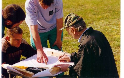
Professor Kola and members of his team at Belzec
The methodology used during Professor Kola's investigations conducted during 1997 to 1999, was consistent: the area to be examined was marked out to a fixed grid system at 5 meter intervals. Exploratory boreholes to a depth of 6 metres were made, obtaining core samples of the geological strata. A total of 2,001 archaeological exploratory drillings were carried out and were instrumental in locating 33 mass graves of varying sizes. From these exploratory drillings, many graves were found to contain naked bodies in wax-fat transformation and carbonised human remains and ashes were identified. The investigating personnel were divided into three teams, each working at a table to record data, as soil samples were withdrawn and examined. Using a map of the area to a scale of 1:1,000 prepared by the District Cartographic Office in Zamosc, a Central Bench Mark (BM 2007) was utilised as the reference point from which the archaeologists worked. Positive data and negative findings were recorded before replacing the soil samples in the boreholes.
Area of Mass Graves
During its first phase, Belzec was the scene of much experiments in the development of procedures and logistics of mass extermination by gas and the burial of corpses, under the watchful eye of commandant Christian Wirth. The camp structures and mass graves during the first phase in Belzec were concentrated along the northern fence, leaving the majority of the camp area unused, but ready for utilisation and expansion at a later date.
The two distinct phases of the gassing operations may be identified by the arrangement of the mass graves and camp structures between the graves. Thus, the apparent proliferation of small wooden structures between the graves of the first phase may have been temporary barracks for the Jews of the 'death brigade' employed in digging the mass graves, and shelters for the guards. Three of the smallest wooden structures, arranged at intervals, around the west and south part of the grave field from the first phase suggest watchtowers overlooking the grave digging area. The structures in the southern half of the camp area, date from the second phase.

The mass graves are numbered as they appear on the plan above, and are located looking into the camp from the main gate, with the forester's property on the right. On the right, the graves marked 1-6 are grouped together. These were the graves located by the investigators during the 1997 excavations, and it was believed these were the last series of graves dug in late 1942, when gassings ceased.
Graves 12 and 14 to 20, situated along the northern fence, were in accordance with the statements made by eye-witnesses covering the period February to May 1942. These graves probably contain the remains of Jews from the Lublin and Lwov Districts deported to the Belzec camp between mid-March and mid-April 1942, along with the remains of early transports from the Lvov ghetto and the transit ghettos at Izbica and Piaski. It is also probable that the remains of German Jews deported from the Reich in April and May 1942, are also located here.
Graves 10, 25, 27, 28, 32, and 33, all contain a layer of lime covering decomposed human remains. It is probable that these graves also date from early transports when the local authorities complained about the health hazard caused by the smell of decomposing corpses in open graves. Chloride of lime was spread over the six still open mass graves, identified above, in an effort to avoid epidemics breaking out. Evidence of the subsequent failed attempt at cremating corpses in graves may be found in the small graves near the northern fence: 27, 28, and 32, in each of which a layer of burnt human remains and pieces of carbonised wood were found. The bottom of each of these graves was lined with a layer of burnt human fat.
The preparation and digging of these graves would appear to have been made on an ad-hoc basis with the early graves located in the north-eastern part of the camp. Many graves were close together and when the exhumation and cremation work commenced in November 1942, the sides of the graves would have collapsed, thereby rendering any accurate record of grave dimensions difficult. This suggests a hurried sealing of the ground, destruction of any identifiable border, which in turn made the archaeologists work even more difficult and their findings less precise. In addition, a mechanical excavator was used to remove the top layer of soil and remove the corpses, and then refill the pits with the cremated human remains and ash.
It has been suggested that some of the smallest graves, Numbers 13, 27, 28, 32, and 33 could have been the execution pits in which the old, sick and infirm Jews were shot during the first phase, while graves 2, 21, and 23, could be the execution pits from the second phase. The smaller graves correspond with sketches and written descriptions of the camp layout during the second phase (July 1942 - December 1942) by members of the former SS-garrison.
From the evidence uncovered by the 1997 -98 investigations, the SS -garrison in Belzec did not destroy all traces of the death camp. Their aim was to disguise the enormity of the numbers buried in the camp. In the clear-up operation after burning the corpses, the cremated human remains, as well as the remnants of the burnt-down wooden barracks and demolished solid structures, were simply dumped into the pits and covered over. Solidly constructed cellars beneath certain buildings were also used as refuse pits into which were thrown items of glass and metal objects, which could not be completely destroyed by fire. The cellars, just like the graves, were simply filled-in with soil.
Mass Graves Numbered 1-33 Are listed in the Order of Discovery
Grave Pit No. 1
The grave pit No. 1 was situated in the north-western part of the camp. It was in the shape of an irregular rectangle with the size of 40 meters by 12 meters and with a depth of 4.80 meters. The pit was filled with bodies in wax-fat, transformation; from the depth of about 2 meters burnt human bones and charcoal were mixed together. Such contents were already found at the depth of about 20-30 cm's from the surface. Burnt human bones and charcoal were also found samples drilled out in the area around the pit. Underground waters appeared at the depth of 4.10 meters. The estimated volume of the pit was about 1,500 meters.
Grave Pit No. 2
Located in the north-eastern part of the camp. Dimensions of the grave were determined as 14 meters by 6 meters, with the depth of 2 meters. Crematory grave with the volume of about 170 meters.
Grave Pit No. 3
Located in the southern part of the camp. This was the first mass grave, the location of which was positively identified from a Luftwaffe aerial photograph taken in 1944. It appears as a T-shaped white patch and has the appearance of being the biggest grave in the camp. Dimensions of the grave were determined as 16 meters by 15 meters and a depth of over 5 meters. The grave contained a mixture of carbonised wood, fragments of burnt human bones, pieces of skulls with skin and tufts of hair still attached, lumps of greyish human fat, and fragments of unburned human bones. The bottom layer consisted of putrid wax-fat transformation. The volume of the pit was about 960 meters.
Grave Pit No.4
The pit was registered at the borderline in the southern part. The grave was in the shape of a rectangle and dimensions were determined as 16 meters by 6 meters. The drilling was suspended at the depth of 2.30 meters because of a layer of bodies in wax-fat transformation. The volume of crematory part is about 250 meters.
Grave Pit No.5
Located in the south-western part of the camp. The grave had the shape of an irregular lengthened rectangle with the dimensions of 32 meters by 10 meters, reaching a depth of over 4.5 meters. It was of a homogenous content. Studies of its crematory layers structure suggested multiple filling of the grave with burnt relics. The layer with the biggest thickness and intensity of crematory contents appeared in the lowest part of the pit and was about 1 meter thick; above 50 cm thick layer of soil, 4 following layers of crematory remains appeared, separated from each other with 20-30 cm layers of sand. The volume of the pit was about 1350 meters.
Grave Pit No. 6
This grave was located in the south-central part of the camp. It had the shape of a lengthened rectangle, with the dimensions of 30 meters by 10 meters with a depth of 4 meters. The ashes were scattered around the grave, reaching the depth of 1 meter. The grave contained homogenous crematory contents. The volume of the pit was about 1200 meters.
Grave Pit No. 7
This grave was located in the north-central part of the camp, where one of the concrete pylons, commemorating the camps victims was erected during the 1960's was situated. The shape of the pit similar to a high trapezoid, with dimensions of 13 meters by 14 meters, and a height of about 27 meters, and the depth of 4.5 meters. The grave was homogenous with crematory ashes and sand. The lowest layer with the thickness of over 1.5 meters contained the most intensive traces of body ashes. The upper layer contained brick rubble and stones at the depth of 0.8 meters. The volume of the grave was about 1600 meters.
Grave Pit No. 8
This grave was located in the south-western part of the camp. The second pylon from the 1960's was erected over it. The general shape of the grave was in the shape of a lengthened rectangle, with the dimensions of 28 meters by 10 meters. Additional drilling revealed that 2 neighbouring graves existed, joined together as one, at a later date. The depth of the original grave was about 4 meters, and the bottom layer consisted of dense crematory remains. The fillings were covered with 20 -30 cm of sand, coming probably from the soil separating the graves. The ditch created that way, with the depth of 2 meters was filled with body ashes, charcoal and brick rubble. The volume of the pit amounted to about 850 meters.
Grave Pit No. 9
A relatively small grave with an irregular shape was located in the eastern part of the camp, between the pylon, and the present line of the camp enclosure. The pit was an irregular shape with the dimensions of 8 meters by 10 meters. The depth exceeded 3.80 meters. The contents of the pit were crematory remains and charcoal. The estimated volume of the grave amounted to about 280 meters.
Grave Pit No. 10
One of the biggest graves located in the north-central part of the camp. It was rectangular in shape, with dimensions of 24 meters by 18 meters. The grave was very deep, over 5.20 meters, and the drills were stopped because of bodies in wax-fat transformation and underground waters. One drill at the depth of 4.40 meters revealed the appearance of several centimetres layer of white sand mixed with rich lime. Over body layers there were some levels of crematory remains, mixed with charcoal in turn with layers of sandy soil. The estimated volume of the grave amounted to about 2100 meters.
Grave Pit No.11
This grave of relatively small volume was located in the north-eastern corner of the camp. The dimensions of the grave was 9 meters by 5 meters with a depth of 1.90 meters. A small layer of crematory remains was found. At the depth of about 50 cm remains of musty wood was located. The estimated volume of the grave amounted to about 80 meters.
Grave Pit No.12
Located immediately to the north of grave pit 10, an L-shaped grave with the foot measuring 20 meters, with a depth that reached below 4 meters. The grave contained crematory in layers. In the separating layers charcoal and brick rubble was found. The volume of the grave amounted to about 400 meters.
Grave Pit No. 13
Located towards the west of grave No. 12. One of the concrete ever-burning fires from the 1960's was placed over it. Dimensions of the grave which was trapezoid in shape, was determined as 12.50 meters by 11 meters and a height of 17 meters, with a depth reaching up to 4.80 meters. The grave contained body remains of mixed character. There was a layer of bodies in wax-fat transformation with a thickness of about 1 meter in the bottom part; directly over it there was a layer of sand and lime. Above there were layers of crematory remains and charcoal. The volume of the grave was estimated at 920 meters.
Grave Pit No. 14
The vast grave basin of an irregular shape was located in the western part of the fenced camp area. The grave's dimensions were 37 meters by 10 meters. The average depth of the grave was about 5 meters. The grave contained crematory remains, and the drills revealed pieces of glass and plastic. The graves volume was over 1850 meters.
Grave Pit No. 15
Located in the north-western part of the camp. This grave on its surface had the second concrete ever-burning fire from the 1960's. The grave was in the shape of a rectangle, and the dimensions were about 13.50 meters by 6.50 meters and reached the depth of about 4.50 meters. The grave contained crematory remains. The estimated volume was about 400 meters.
Grave Pit No.16
Located in the north-western part of the camp, under the third existing concrete ever-burning fire. The grave was in the shape of a rectangle with the dimensions of 18.50 meters by 9.50 meters, with the depth of about 4 meters. In the bottom layers lime presence was found. The grave contained crematory ashes in layers with sand. The shallow drilling close to the grave confirmed the presence of burnt bones. The volume of the grave amounted to about 700 meters.
Grave Pit No. 17
Located east of grave No.16. The grave had the shape of a rectangle with the dimensions of 17 meters by 7.50 meters with a depth up to 4 meters. The grave contained crematory ashes. Burnt bones were also placed in layers with sand. A layer of rich lime was found in three drills at the depth of about 3 meters. The volume of the grave amounted to about 500 meters.
Grave Pit No.18
Located in the eastern part of the camp, to the east of the grave pit No. 15. The grave was in the shape of a rectangle with the dimensions of 16 meters by 9 meters with a depth of about 4 meters. The grave contained crematory ashes and charcoal. In the bottom part traces of lime were found. The volume of the grave amounted to about 570 meters.
Grave Pit No. 19
Located in the eastern part of the camp, directly under the first concrete fire. The ditch had the shape of a square with sides of about 12 meters. The depth of the grave was not more than 4 meters. The grave contained crematory ashes with a high density of human bones and charcoal. The volume of the grave amounted to about 500 meters.
Grave Pit No. 20
This grave was situated directly to the south of Grave Pit No.12 and its western part exceeded slightly the present enclosure of the camp. The grave had the shape of a rectangle with the dimensions of 26 meters by 11 meters, with a depth of 5 meters. The grave contained layers of crematory remains and charcoal. The farthest western drill contained not only body ashes, but pieces of musty paper and wood, a piece of a nail and brick rubble. The volume of the grave amounted to about 1150 meters.
Grave Pit No. 21
Located centrally in the camp. This was a relatively small grave 5 meters by 5 meters, with a depth of 1.70 meters. The grave contained crematory ashes which were reported at a depth of 70 cm. The volume of the grave amounted to about 35 meters.
Grave Pit No. 22
Located in the eastern part of the camp, under the eastern end of the alley, running in front of the concrete pylons symbolising the graves, erected during the 1960's. The grave had a shape close to a flattened triangle with the base of about 9 meters and the height of 15 meters. The grave contained crematory ashes and sand. The estimated volume of the grave amounted to about 200 meters.
Grave Pit No. 23
Located in the central part of the camp. The grave was in the shape of a rectangle with the dimensions of 16 meters by 8.50 meters, with a depth exceeding 4 meters. The grave contained crematory ashes. The estimated volume of the grave amounted to about 550 meters.
Grave Pit No.24
Located in the southern part of the camp, just to the south of the fifth concrete ever-burning fire. The grave had the shape of a lengthened rectangle with the dimensions of 20 meters by 5.50 meters with the depth of about 5 meters. The grave contained irregular layers of crematory ashes and lime. The lowest layer of ashes with the thickness circa 60 cm was covered with about 40 cm thick layer of sand. Above that regular surface of body ashes and sand were reported. The estimated volume of the grave amounted to 520 meters.
Grave Pit No.25
Located in the southern part of the camp under the alley, between the fifth and the sixth ever-burning fire. The dimensions of the grave was about 12 meters by 5 meters, with a depth of about 4 meters. The bottom of the grave contained 40 -50 cm layer of bodies in wax-fat transformation covered with a layer of lime. Above that there was a layer with the thickness of about 60 -80 cm, covered with an 80 cm layer of sand. Over it was another intensive layer of burnt wood with a thickness of 80-100 cm covered with a surface bed of humus-like sand. The estimated volume of the grave amounted to 250 meters.
Grave Pit No.26
Located in the south central part of the camp, under the alley close to the sixth ever-burning fire. The grave had the shape of a rectangle with the dimensions of 13 meters by 7 meters with a depth of over 4 meters. The grave contained crematory ashes, with clear layers of ashes, charcoal and sand. The estimated volume of the grave amounted to 320 meters.
Grave Pit No. 27
Located in the central part of the camp, towards the west of grave pit No. 25. It was the shape of a lengthened rectangle with the dimensions of 18.50 meters by 6 meters with a depth of about 5 meters. The bottom part of the grave consisted of nearly 1 meter thick layer of bodies in wax-fat transformation, above it there was a 20-25 cm thick layer of lime - over 2 meter thick intensive layer of charcoal with small amounts of crematory ashes. The estimated volume of the grave amounted to 450 meters.
Grave Pit No.28
Located in the central part of the camp, towards the west of grave pit No. 27. Two clear layers of bodies in wax-fat transformation covered with lime were reported. Above them was found intensive structures of charcoal without body ashes. The estimated volume of the grave amounted to 70 meters.
Grave Pit No. 29
Located in the central part of the camp. It was the shape of an irregular rectangle with the dimensions of about 25 meters by 9 meters with a depth of about 4.50 meters. The grave contained crematory ashes. The estimated volume of the grave amounted to about 900 meters.
Grave Pit No.30
Located in the central part of the camp. The dimensions of the grave was 5 meters by 6 meters. The crematory remains were noted only from the depth of 2.70 meters. Above that a high density of charcoal was found. The estimated volume of the grave amounted to about 75 meters.
Grave Pit No. 31
A relatively small grave located to the north from grave pit No. 30. The grave was probably in the shape of a rectangle with the dimensions of 9 meters by 4 meters, with a depth of 2.60 meters. The grave contained crematory ashes, mixed with sandy soil. The estimated volume of the grave amounted to about 90 meters
Grave Pit No.32
Located in the north western corner of the presently enclosed area of the camp. The grave was the shape of a lengthened rectangle with the dimensions of 15 meters by 5 meters, with the depth of over 4 meters. The grave contained bodies in wax-fat transformation, covered with lime at the depth of about 3.60 meters. Above that there was a mixed structure of crematory ashes with charcoal. The estimated volume of the grave amounted to about 400 meters.
Grave Pit No. 33
A relatively small grave located in the north-western corner of the presently existing borderline of the camp, which went beyond the fence. The grave had dimensions of 9 meters by 5 meters, with a depth of about 3 meters. The grave contained the remains of crematory ashes and charcoal. The estimated volume of the grave amounted to about 120 meters.
The total surface of the mass graves was estimated at 21,000 cubic meters. It was believed that at least a dozen graves still contain un-burnt, partially mummified or decomposing corpses. Exactly why the SS did not empty all the graves and destroy the traces of their crimes is not known.
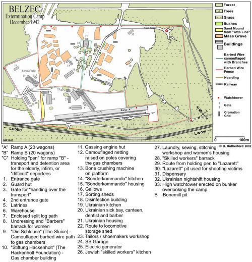
Plan of Belzec December 1942 (William 'Billy' Rutherford)
Camp Structures
The focus of the investigations moved away from the graves to where the 'resettlement' transports had terminated inside the camp - the so-called 'Ramp.' Here the Jews disembarked from the wagons to be addressed by the camp personnel, before moving on to the undressing barracks and subsequently the gas chambers. The archaeological team carried out four excavations and located what was believed to be the end of the railway spur line. The investigating team selected a 75 meter long section at the south-western end where the former railway sidings emerged between two earthen banks, 8 -10 meters apart. The terrain at this location was forested and uneven, rising steeply to the east.
Four excavations were carried out:
1. At right angles to the line of the ramp, which concluded that the rail -link did not extend this far.
2. Located 15 meters north-west of excavation No. 1, measured 14 meters by 1 meter and 1 meter deep. There were positive findings: traces of a standard gauge railway track -bed; and a layer of crushed brick and cinders (ballast) covered with black grease. A second track-bed was found running parallel and to the east of the first. Six samples of oil were taken away for further analysis.
3. Excavations were carried out parallel to excavations No.1 and 2, some 30 meters north-west of excavation No.2. Further indications of track-beds in parallel were found.
4. The fourth excavation was located 15 meters north-west of excavation No. 3 and measured 8.5 meters by 1 meter, by 2 meters deep. Further evidence of the twin track system was found.
Also at the unloading ramp a Polish railway switch lamp, in remarkably good condition was found, this was probably a pre-war item, used on the Polish Railways. Another find at the unloading ramp was the lid of a silver cigarette case, using a metal detector. On the inside of the case was the inscription: Max Munk, Wien 27. This cigarette case of Max Munk, probably belonged to a man born on April 17, 1880. He was deported from Prague to Theresienstadt and from there on April 1, 1942, deported to the transit ghetto of Piaski in the Lublin district. From Piaski it would appear his journey ended in Belzec.
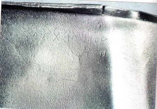
Max Munk Cigarette Case Lid found at the Belzec unloading ramp (P. Bielecki)
The Investigation team identified through excavations a number of structures, such as the garage, and a generator housing, but the purpose of some of the structures could not be identified. The structures were given the alphabetical lettering A- H. Within the southern area of the camp, the structure that was recorded as Building D was the largest structure in Belzec that was found during the excavations.
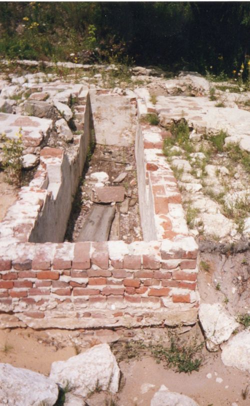
Belzec -Garage Foundations - July 2000 (Chris Webb Private Archives)
The foundations had managed to be preserved to date, whereas the upper parts had been completely pulled down. It was determined that the structure consisted of at least 3 rooms. The outside walls rested on continuous stone footings 100-140 cm wide. The dimensions of this structure was 26 meters in length by 12 meters wide. The building had at least 6 equal rooms with the dimensions of about 16.60 meters by 3.80 meters, separated by an inside wall. Only the southern (6th) room was additionally divided into two smaller ones. The rooms had concrete floors on brick rubble.
In one case only the inside room was covered with flat lime-stones with cement sliding surface forming a regular floor. A large part of that floor remained along the outside north-western wall and in the smallest part in the eastern corner of the room. There was a channel made of brick in that room. The dimensions of the room was 6 meters by 1 meter. The walls of the channel were made of eleven lines of bricks plastered from the inside. The total thickness of these walls together with the plaster was about 30 cm. The bottom of the channel, serving originally as an inspection pit for repairing vehicles, was covered with a concrete floor. Over it there were boards placed horizontally, being a kind of insulation from the bottom for people working there.
Four cavities with the length of 0.55 meters, height 0.24 meters and depth of 0.14 meters were situated evenly in the longer walls at the height of 0.80 meters from the floor and with the distance of 1.20 meters from both top walls. They probably served as tool and light shelves for the people working there. The inspection pit was 1.22 meters deep. The conclusion reached was this structure served as a garage.
The layers of the interior contained numerous objects, such as pieces of combs, medicine or perfume bottles, a lead seal, gun cartridges, spoons - complete or in pieces, forks, knives, different metal boxes, mugs, a metal pot, elements of rail fastenings. Particularly interesting was a set of 304 pieces of concrete rings, with the diameter of about 6 cm and I cm thickness on which 5 number figures had been pressed. They were excavated at the area of a stone floor in the western part of the central room.
Robin O'Neil, English historian was present during the investigations that took place during April 28 1998 and June 4 1998, and he carried out a daily video and photographic record, which he kindly donated to the Holocaust Historical Society. Chris Webb visited the Belzec site in July 2000, along with Michael Tregenza, another English historian, who is an expert on the Belzec death camp. Some photographs were taken at the site, and in the Regional Museum at Tomaszow Lubelski, including one of the gassing outlet pipe, which have enhanced this article.
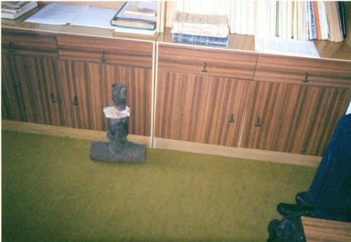
Tomaszow Lubelski Regional Museum - Gassing Outlet Pipe -July 2000 (Chris Webb Private Archive)
Sources
Andrzej Kola, Belzec, -The Nazi Camp for Jews in the light of Archaeological Sources - Excavations 1997 -1999, The Council for the Protection of Memory of Combat and Martyrdom, USHMM, Warsaw - Washington 2000
Robin O'Neil, Belzec - Stepping Stone to Genocide, JewishGen. Inc New York 2008
www.HolocaustResearchProject.org
Plan of Belzec, courtesy of William 'Billy' Rutherford
Plan of Excavation Site - Robin O'Neil
Photographs - Chris Webb, P.Bielecki
Thanks to Robin O'Neil, Michael Tregenza, and Victor Smart
© Holocaust Historical Society 2018

